
Project is first in Ohio that will capture 360-degree imagery of the Dayton-area's trails and landscape for Google Maps.
Google to map trails at Five Rivers MetroParks
First-in-Ohio Google project captures images of recreational trails
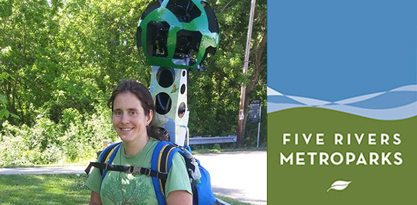
GOOGLE STREET VIEW TREKKER PROGRAM UNDERWAY IN DAYTON
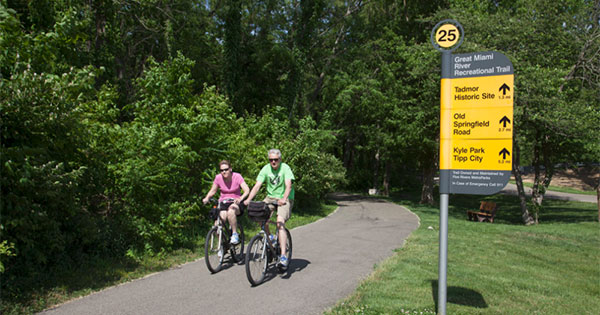
Five Rivers MetroParks has partnered with Outdoor Adventure Connection to participate in the Street View Trekker loan program. When completed, everyone will have access to explore panoramic street view-like “treks” of regional hiking, mountain biking, equestrian, water and paved trails in Google Maps.
From now through August, volunteers from MetroParks and Dayton Hikers will be hiking local trails with the Street View Trekker. The Trekker weighs approximately 40 pounds and is the size of a large backpack. It’s approximately four feet in height when set on the ground and, when worn, the camera system extends two feet above the operator’s shoulders. There are 15 lenses at the top of the mast, each posted in a different direction. The Street View Trekker also will be mounted on kayaks and electric buggies to capture the region’s water, equestrian and paved trails.
“Google Trekker will create a 360-degree interactive view of our trails and helps make Google Maps more comprehensive and useful for all,” said Amy Dingle, director of outdoor connections for Five Rivers MetroParks. “This will help with trip planning and be a great asset to showcase Dayton, Ohio, as the Outdoor Adventure Capital of the Midwest.”
This marks the first Google Trekker project in the state of Ohio.
Google is now enabling third parties to borrow its Street View Trekker and collect imagery of unique places and local communities. The technology enables visitors to connect with special places in the United States in a new and immersive way.
After volunteers finish gathering imagery, all the data must be processed before it’s added to Google Maps. This process can take several months. Five Rivers MetroParks will notify the community once these images are available online.
ABOUT FIVE RIVERS METROPARKS
Five Rivers MetroParks is a nationally renowned park system composed of natural area parks, gardens, river corridors, urban parks and a network of paved trails,celebrating more than 50 years of preserving green space and natural areas. MetroParks protects the region’s natural heritage and provides outdoor experiences that inspire a personal connection with nature. Educational programs and recreational opportunities are offered year-round for all ages. To learn more about Five Rivers MetroParks, visit www.metroparks.org or call 937-275-PARK.
Links & Tags
Five Rivers MetroParks.